
North Tweeddale Routes
At the foot of the Pentland hills, North Tweeddale is at the northwestern limit of the Scottish Borders. The legacy of old drove roads, Roman roads, disused railways, pedlars paths and other tracks on which the development of many of the local settlements was based, now form the basis of the 350km South of Scotland Countryside Trails (SoSCT) network for riders, walkers and cyclists to enjoy.
Larger scale maps should be used to follow routes on the ground, such as OS Landranger Maps 1:50,000 no. 72 lUpper Clyde Valley) and Explorer Maps 1:25,000 no. 344 (The Pentland Hills) and no. 336 (Broughton and Biggar).
Route Description
This is a network of paths based around West Linton, Romanno Bridge, Blythe Bridge, Carlops and Newlands with links to other longer distance trails. The main drove road between the Highlands and markets south of the border runs high up into the hills, intersected by the typically straight road along the foot of the Pentlands built by the Romans to link their garrisons at Biggar and Elginhaugh.
Cauldstane Slap
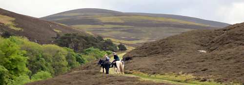
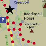
The old drove road from West Linton heads up the tarmaced public road to Baddinsgill, beyond which a stony track climbs north, gradually becoming grassier to the breach in the Pentlands at the Cauldstane Slap. From here a narrow, unsurfaced path leads on northwards.
Not for nothing was the Slap known as “The Thieves Road”. Border Reivers, Moss Troopers and robbers galloped through the pass on night raids. Wrapped in their plaids, the drovers slept beside their herds and flocks, determined to defend them with dirk and staff. But cattle and sheep were often driven off and blood shed.
Cairns Castle, the ruins of which can still be seen near West Cairn Hill at the eastern end of Harperrig Reservoir, was the stronghold of the Warden of the Slap who endeavoured to protect those using the pass.
Old Roman Road (west)
This road once linked the Roman garrisons at Biggar and Elginhaugh and follows the contour along the side of the Pentland Hills, and is therefore relatively level but largely unsurfaced. An informal grassy path suitable for horses winds up to the summit of Mendick Hill, affording views of the Lyne Valley below.
Five hundred metres north of here the remains of a large Roman marching camp have been found, extending to over 11ha. The arched bridge between here and South Slipperfield was erected in 1620. Further up the hill, in the mid 1990s seasonal drops in water levels at West Water Reservoir revealed a 4,000 year-old Bronze Age burial ground. Finds from the graves included a unique necklace with a strand of lead beads – the earliest evidence for the use of metallic lead in Britain. Stone burial cists recovered by archaeologists have been resited on a mound about 100m northeast of here.
North Slipperfield to Garvald
This route makes an enjoyable circular riding path in conjunction with the old Roman road, with option for a longer trail through to Dunsyre, or linking to other paths over the Pentlands and to the Covenanters Grave. This track is a hill path with uneven surface and variable gradient and the moorland sections of the path are relatively exposed and can be wet and boggy at times. Along the old drove road to Garvald, you will pass Nether and Upper Cairns - prehistoric burial mounds erected more than 4,000 years ago.
Old Roman Road (east)
From Lynedale, the old Roman road continues northeast to Carlops as a wide stony track of varying gradient and uneven surface.
Stonypath to Baddinsgill
The inviting grassy track is ideal for horses and is following the contour of the hill parallel and to the east of the old drove road south of Baddinsgill links via a stony track to the old Roman road south of Stonypath. An ideal medium-length circular route in conjunction with the quiet road to Baddinsgill.
The Catwalk
As its name implies, this narrow footpath is perched along the side of a gorge and is suitable only for sure-footed walkers. A short link joins up with The Loan to form a circular walk.
The Loan
Sections of the stony road climbing northwest from West Linton to join the Roman road near Stonypath have been improved through Tweed Trails, but the surface remains unconsolidated with varying gradient.
Kaimes
A new path climbs up a stony farm track to the aerial, levelling out onto a grassy track, skirting down around the back of Kaimes House to an attractive path alongside a shelterbelt, and linking down through fields to Halmyre along farm tracks.
John’s Path
From Blyth Bridge, an attractive informal grassy footpath follows the west bank of the Tarth Water south, linking back to the public road towards Castlecraig. The path is named after John Shaw, the dedicated local volunteer who initiated this path.
Old Coach Road
The old road between Blyth Bridge and West Linton is now an enjoyable gently undulating track, grassy at the southern end and stony towards the north, readily accessible but with the feeling of being well off the beaten track.