
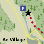
Ae Forest Routes
This route for horse-riders, cyclists and walkers through Ae Forest is part of the 350km South of Scotland Countryside Trails (SoSCT) network, linking Dumfries & Galloway with the Borders. Based mainly on forest tracks and minor roads, this linear route takes in the market town of Moffat and offers opportunity to visit the Samye Ling Tibetan Monastery at Eskdalemuir. It links to the old Roman Road from Eskdalemuir to Craik and further on to Hawick.
Larger scale maps should be used to follow routes on the ground, such as OS Landranger Maps 1:50,000 no. 78 (Nithsdale and Annandale) and Pathfinders 1:25,000 no. 495 (Moffat), no. 505 (Thornhill), no. 506 (St Ann’s and Boreland) and no. 517 (Dunscore and Ae).
Route Description
Ae - Eskdalemuir
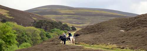
Ae Forest offers a network of forest tracks and minor roads for horse-riders, cyclists and walkers of all ages and abilities to enjoy throughout the year. The forests are managed for timber production, recreation and conservation. Birds of prey such as short-eared owl, buzzard and goshawk regularly nest and hunt in the forest.
The views along the Ae Forest Route are forever changing. As you start to climb uphill with your horse away from Ae look south to the Solway Firth and Criffel. On a clear day you see as far as the Lake District hills. As you follow the riding trail further north Queensberry and Wee Queensberry come into view and dominate the skyline. Further north still to Earshaig the Southern Upland and Moffat Hills form a backdrop to the narrow Crooked Road winding its way down to Beattock.
Eskdalemuir – Hawick
The old Roman road from Eskdalemuir to Craik, and former drove roads east to Hawick, provide a linear link across the remote hills between routes in Dumfries and Galloway and the Borders. Enjoy the beautiful view at Craik summit. A circular mound marks the remains of what is thought to have been a Roman signal station. Craik Cross Hill seems the natural choice of location for a signal station given the clear views to other known Roman sites at Burnswark, Ruberslaw and Eildon Hill North.
The Roman road through Craik is now visible only as a line through the trees, but at one time echoed to the sound of Roman armies on the march as they defended the northernmost part of their empire. The road ran in a straight line to provide the most direct link possible between the Roman forts of Raeburnfoot at Eskdalemuir with Trimontium near Melrose.
Messengers and relay riders are known to have been the most common forms of communication used by the Romans, but a faster means of communicating was essential to the co-ordination of the Roman military in times of crisis. While standards and bugle blowing would be effective over short distances, lighted beacons would have been the obvious choice for longer distance signalling. Smoke would be visible by day, and light from the beacon fires visible by night. The beacons could be combined to form chains and relay networks, and the only equipment or expertise required was the ability to light a fire.
Current Restrictions
Please note that there is a short steep section between Moffat and Eskdalemuir on this route. You may want to lead your horse up and down this section