
East Tweeddale Routes
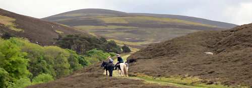
Tweed Trails are the Scottish Borders section of the South of Scotland Countryside Trails (SoSCT) project. The Innerleithen & Walkerburn area offers ample opportunities for horse riding and walking from sheltered strolls along the banks of the River Tweed, Walker Burn or Leithen Water, to more strenuous rides or hikes up the surrounding hills. Forest tracks offer year-round routes for horse-riders, and in the drier months many of the longer distance hill routes are also suitable for multi-use. Tweeddale is a haven for cyclists - Glentress and Elibank and Traquair Forests boast world-class mountain bike routes.
Larger scale maps should be used to follow routes on the ground, such as OS Landranger Maps 1:50,000 no. 73 (Peebles, Galashiels and Selkirk) and Explorer Maps 1:25,000 no. 337 (Peebles and Innerleithen).
Route Description
Minch Moor Road
The Minchmoor Road was at one time the main route across southern Scotland and the old road east from Traquair has been in use for over 800 years. Climbing steeply between twin dykes to the bothy set at the edge of Elibank and Traquair Forest, the stony track climbs up through trees to the open moor land of the Minch Moor. There are miles of inviting grassy paths and the most stunning views over the rolling border hills at the top of the Minch Moor.
For a longer riding route, continue east on the Southern Upland Way to the Three Brethren, Yair and Selkirk, or branch south at Brown Knowe along the grassy track, which leads down to Yarrowford. Other hard forest tracks and narrower informal paths offer infinite permutations on these main routes for walkers, cyclists and horse-riders.
This is the route by which Montrose and his cavaliers fled from Philiphaugh. Tales of buried treasure cling to Minchmoor, dating back to conflicting legends. One tells of Montrose throwing his treasure chest into the dark Mystor pool in Yarrow, telling the Devil to keep it for him until he returned. Another legend says that Montrose cast his chest in at the door of a cottage at Foulshiels before galloping on to the safety of Traquair.
Glengaber
This riding trail branches south along the forest road above the bothy and leads out of Elibank and Traquair Forest onto open hill, from where an informal multi-use grassy path winds its way to the former farm steading at Glengaber. Turning north, a track of varying gradient provides an enjoyable route back across open hill and enclosed fields to Traquair via Damhead. Alternatively, a grassy track leads south from Glengaber to Tinnis or Yarrow, with option for a long distance circular route in conjunction with the Minch Moor Road.
Cardrona Forest
From Howford, the stony farm track winds up to Grieston Quarry (now disused), from where a new path has been created to provide a multi-use off-road link to the path network within Cardrona Forest.
Leithen Water Path
New paths have been developed to create a new short-medium length circular walk, following a narrow relatively level but unsurfaced path up the west bank of the river to the old weir. A new path along the western edge of the forest, above the golf course, leads south back through the forest to Innerleithen parallel to the east bank of the Leithen Water. This latter path, sheltered within the trees, is ideal for year-round multi-use, with option for longer routes using paths and tracks in Cademuir Forest.
Kirnie Law/ Walker Burn Path
From the northern end of the Leithen Water Path, or direct from the car park by the golf club house, forest tracks lead onto a path which climbs through the trees to Kirnie Law. Although the gradient is fairly steep and at times the path can be rough, the panoramic views from this vantage point are worth the climb. From here, a variety of paths can be followed, either leading back down to Innerleithen, or east via Priesthope to Walkerburn. A new path winds up the west bank of the Walker Burn to join with the track leading into Caberston Forest and Priesthope. The path has been surfaced to support multi-use, but includes moderate gradient in places.