
Central Tweeddale Routes
Nestled in the heart of the Tweed Valley, within easy reach of Edinburgh, Glasgow and the North of England, Peebles is an ideal location for walking, cycling and horse riding. The rolling hills and extensive woodland of the Tweed Valley offer unlimited scope for those looking for varied terrain, while for those seeking more of a challenge, there are long distance hill paths, some of which are suitable for horse riding as well as walking. Tweeddale is a haven for cyclists - Glentress Forest boasts world-class mountain bike routes. This route is part of the 350km South of Scotland Countryside Trails (SoSCT) network.
Larger scale maps should be used to follow routes on the ground, such as OS Landranger Maps 1:50,000 no. 73 (Peebles, Galashiels and Selkirk) and Explorer Maps 1:25,000 no. 337 (Peebles and Innerleithen).
Route Description
Crookston Burn Path
A level, dry, surfaced footpath leads from Glen Road through Jubilee Wood to Haystoun Estate. A new unsurfaced footpath runs through woodland south down “The Cut” alongside the Crookston Burn Bonnington Farm road. Link this route with the estate access road to create a level circular walk, or explore the new unsurfaced path which links through the shelterbelt from The Cut to Bonnington Road. Mainly sheltered under mature trees, the path is ideal for year-round use, although the link to Bonnington Road can be wet at times.
Cademuir Forest
A network of sheltered, multi-use trails through the forest, with spectacular views over the Manor and Tweed Valleys from the highest points where trees have recently been felled. The hard forest roads tend to follow the contour, whereas the informal paths through the trees are more uneven and variable in gradient. There are two car parks within the forest, near Bonnington Farm and the Whaum. Alternatively the paths can be accessed from the John Buchan Way behind Tantah House or off Cademuir Hill.
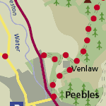
Venlaw
The old coach road winds up as a grassy track to what is now Castle Venlaw Hotel. A firm track leads on past Venlaw Farm and climbs gently up to the western edge of Glentress Forest. Combine this path with the Soonhope Burn path for an enjoyable mid-length circular route, or use it to link in with the many other trails and tracks through Glentress.
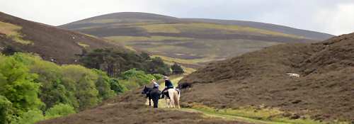
Gypsy Glen
The old drove road south from Peebles starts as a level riding route through an avenue of trees at Gypsy Glen, readily accessible to all ages and abilities. Dropping down to the river crossing, the path surface becomes less well consolidated, and then climbs relentlessly uphill. For several miles the route runs between the twin dykes, which once prevented cattle straying as they were being walked south to Norfolk for fattening prior to their final journey to market in London. The views from the top of Birkscairn Hill are spectacular, but the long climb is not for the faint hearted. The old drove road continues south to Craig Douglas in the Yarrow Valley, but the southern section is not wholly signed and is boggy in places, particularly where there is deep peat. The new Tweed Trails path skirting south of Cardrona Forest links east to Glen Estate, with option for a long distance circular ride or walk back through the Forest.
Old North Drove Road from Standalane
The “North Drove Road”, as it was formerly called, between Peebles and West Linton starts at Standalane Farm, climbing up a stony track between twin dykes to Hamilton Hill. Informal paths leading off around the hill offer opportunities for circular routes, or alternatively continue along the grassy path of the old drove road using the footbridge or ford to cross Kidston Burn, and on to the minor road between the Meldons and Eddleston.
Old North Drove Road – Stewarton to Cloich
The Tweed Trails path north of the Meldons road follows the Stewarton Farm access road, joining up with the Old Post Road with option to head north to Eddleston, south to the Meldons and Lyne, or on west through Cloich Forest to Romanno Bridge and West Linton. The farm access road is firm and dry, but beyond that the track becomes grassier and more uneven, with a steep climb immediately beyond the forest boundary, levelling out through the trees before dropping down to the forest road at Greenside.
Cloich Forest Circular
Following the horse trail and turning north at Greenside, a firm, stony forest road leads out through the forest, past Cloich Farm. From here the public road can be followed past the old observatory, an outstation of Edinburgh University, to join the northern end of the Old Post Road at Shiplaw.
Harehope
Between the Meldons car park and Harehope a firm, relatively level, wide sheltered track snakes through the trees to join with Harehope access road, linking back to the old post road above Green Knowe. The Monks of Melrose owned land at Harehope from 1200 until the reformation.
Old Post Road
From the Meldons public car park north of Lyne, or from the smaller car park alongside the road half a mile north of this, a firm, grassy track heads north through the forest, coinciding with the old drove road near Nether Stewarton. This old track is thought to have been one of the several routes from Edinburgh to Moffat. The small burn across the track can be forded or stepped across. The old post road continues north as a grassy track over enclosed hill ground to Fairydean Burn, where there is the option to branch east to Eddleston or continue north to Shiplaw.
Barony Circular
This multi-use route starts in Eddleston, heading north along the level, tarmac surface of the Old Edinburgh Road through an avenue of lime trees. North of Scots Pine tearooms, the path crosses the main road leading west to Darnhall Mains. Skirting around the steading, a firm, stony farm track climbs west to the old post road at Hare Laws. A dry, relatively level but unsurfaced route leads south through Swiss Cabin Wood, and down a grassy bank to the Barony Castle access road, which leads back onto the public road to Eddleston. For a longer riding route, combine with sections of the Old Post Road or the Cloich Forest Circular.
Tweed River Path
The level, unsurfaced footpath from the centre of Peebles, which winds along the north bank of the Tweed, offers an enjoyable short circular walk via Kerfield Farm. For a longer walk, half a mile east of Peebles, a steep flight of steps at Wirebridge Cottage lead up to the footpath alongside the A72, which can be followed back to Peebles. Directly opposite the steps, a steep footpath on the north side of the A72 climbs up Janet’s Brae, linking to paths in Glentress Forest.